If you have been impressed by images from the eruption of the Icelandic volcano at Eyjafjallajokull, you may well have been looking at pictures from the Satellite Receiving Station at Dundee University.
The station, funded by the Natural Environmental Research Council and based in the university’s Ewing Building, has been receiving satellite images since 1978. It collects data for all kinds of research projects and academic studies in many areas that are not only topical but also far-reaching climate systems, biodiversity, natural hazards, pollution and human health.
It also provides images to news media cross the globe and to the public through free access to its website of major events, whether natural or manmade.
Over its 30 years in existence, that has included events such as the Fastnet yacht race storm of 1979, the Buncefield oil refinery fire in 2005, Greek forest fires and the exceptional winter conditions experienced, particularly here in Britain, over the end of 2009 and into 2010. The archive contains over 130,000 recordings from various polar orbiting satellites plus near real-time and archive images from geostationary satellites that provide global coverage.
Station manager Neil Lonie said, “The station really grew out of academic and student projects of the 60s and 70s in electronics and communications. Over time, expertise and equipment were developed here to improve satellite reception regarded as pioneering work at the university level. From that, the station began to offer the data collecting service and that now extends to projects all over the world and to continuing research in a huge number of scientific fields.
“As well as taking in and archiving data from some of the most sophisticated satellites and communications in the world, our own reception systems and software are designed and developed, built and maintained in-house by our staff.
“It’s not data analysis our remit is to receive and archive material and our main purpose is to provide that kind of information for long-term studies in a number of areas.”
In the marine sector, for example, the Dundee station contributes to research cruises and its data is used to monitor different aspects including sea temperatures and the effects and extent of algal bloom. Where the terrestrial environment is concerned, the data is used for EC monitoring studies of vegetation and crop yield and for things like a bird habitat study of great bustards in Spain. Atmospheric studies can include weather conditions and phenomena and the archive has been used for a study of aircraft contrails.Public interestAccording to Neil, “alongside that, though, there is great public interest in what the station does, especially the images we collect and we make many images freely available through our website. Although we’re relatively small certainly in comparison with something like NASA! we have about 300,000 registrations worldwide for access to free imagery, which can be from individuals, organisations and research projects. Airline pilots often check in before they fly to look over changing weather conditions, for example, and it’s also a service used by flight planning services, satellite operators and national and international meteorological services.”
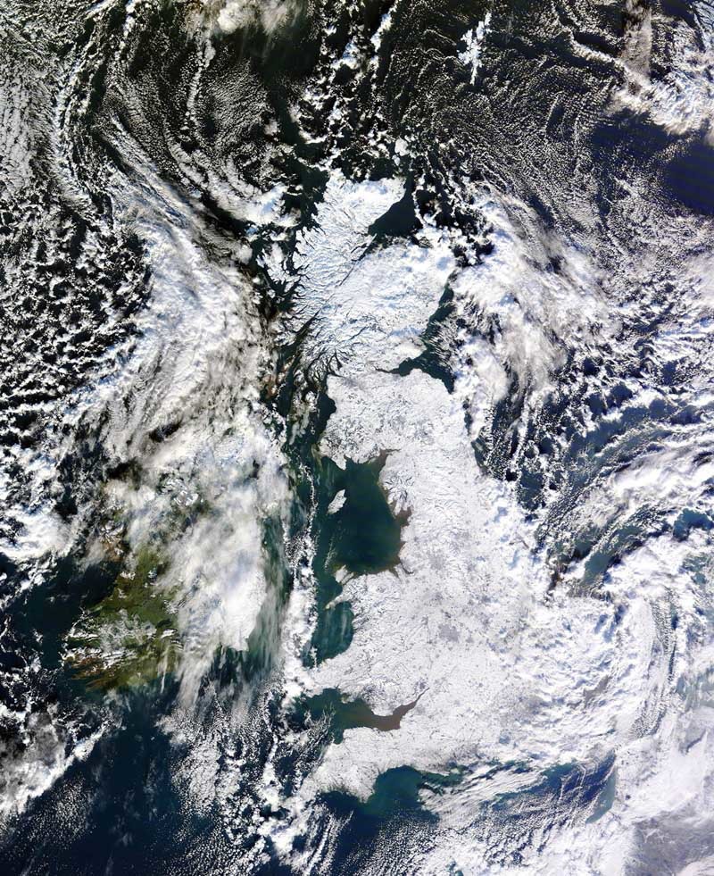
Capturing the moment, whether it is of a natural occurrence or a manmade event, is what seems to capture the public imagination. Stunning images of the entire UK covered in snow which appeared across the newspaper and TV coverage of last winter were received at Dundee from the NASA satellite Terra at just before noon on January 7.
Neil added, “We covered that on our website and every national newspaper in the UK had it. It also appeared on all kinds of TV programmes from news broadcasts and sporting shows to documentaries and BBC2’s Mock the Week. Not content with viewing it on screen or in newsprint, the public also inundated the university with requests for copies of the iconic picture.
“It’s partly the continuous nature of the recording that makes it possible for us to pick up these images but there’s also more than a bit of luck involved. Where the winter snow image was concerned, we were fortunate that for a short time there was virtually no cloud cover as the satellite passed over the UK and the full extent of the snow cover could be plainly seen.”
For more information and archive images visit the station’s website at www.sat.dundee.ac.uk
