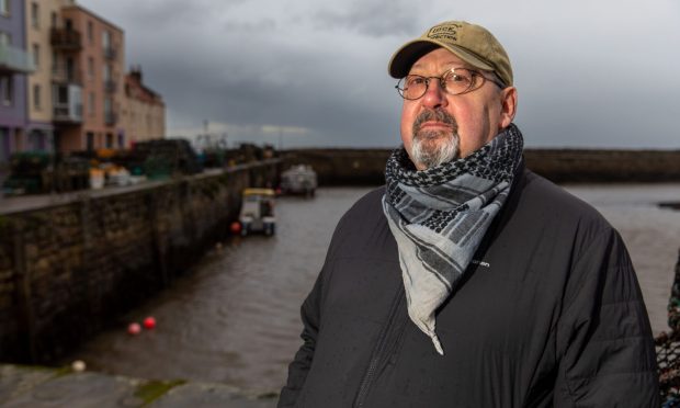
Internationally-renowned marine archaeologist Neil Cunningham Dobson believes the time is getting closer when “big spending” decisions will have to be made to protect the Fife coastline.
New defences might be required – and he believes it maybe that the ongoing “tinkering” to protect the golf links is not enough.
These conversations, he told The Courier, won’t just apply to the golf.
They’ll equally apply to the future of places like St Andrews’ medieval harbour, recently ravaged by storms, and the erosion threatened cliffs at the cathedral – already impacted by climate change.
Where once there was accretion of sand along the coast – where sand would be naturally dumped on the beach to effectively make the land bigger – there is now increasing coastal erosion.
“Instead of the weather and sea and wind directions pushing sand on and building beaches, it’s now taking it away,” said the renowned international ship-wreck hunter.
He is also a former Coastguard officer who sits on St Andrews Community Council and has been involved with fundraising for the storm damaged St Andrews pier and harbour.
“I know myself in the last few years, where we used to get a lot of winds from the east, it’s now more from the west.
“The trend with climate change, sea level rises, temperature changes and everything else points towards greater erosion – and this will come at a price.”
What does climate science say about erosion threat to St Andrews golf courses?
According to a recent climate change study by Climate Central – an organisation comprising scientists who research climate change and its impact – parts of the ‘Home of Golf’ could be under water in less than 30 years.
In a separate study, the Scottish Government’s Dynamic Coast report, which sets out resilience and adaptation options for St Andrews Links, warned that erosion and flood risk are “real and growing threats” to the St Andrews Links.
Projections expect St Andrews to experience sea level rise of up to 0.9 m by 2100, in turn quickening erosion.
Working with Dynamic Coast, we prepared a detailed visualisation showing how St Andrews could look in 2100.
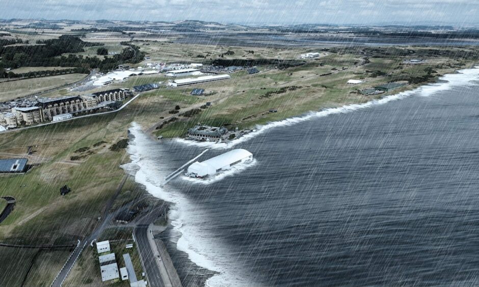
Dynamic Coast research starkly predicts that under a worst case “do nothing” coastal management strategy, the Out Head section of West Sands at St Andrews will “retreat into the links by up to 240 m in the next 30 years and up to 750 m by 2100”.
It’s an issue that’s being taken very seriously by the St Andrews Links Trust.
Shifting coasts are ‘nothing new’
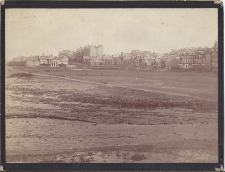
But when Neil reflects on the growing threat to St Andrews golf courses from sea level rise and intense storms, he’s reminded that the coastal erosion threat to the Old Course is nothing new.
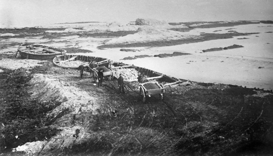
The St Andrean points to 19th century photographs, held by the University of St Andrews Special Collections Unit and St Andrews Preservation Trust, which recall a time when there was just a few yards between the golf links and the beach.
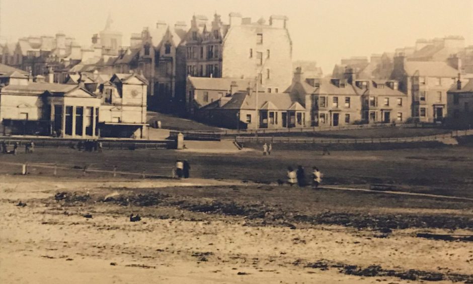
Back then, it became clear to golfers and to the R&A, that the Old Course and the R&A clubhouse – then just 30-feet from the beach – needed a barrier to protect against tidal surges.
It wasn’t uncommon for beach sand and seaweed to be thrown onto the first fairway after severe storms. In those days, bathers used to gather under the north room of the R&A – such was the closeness of the water.
The man credited with ‘saving the gowf’ from the ravages of the sea in 1893 was town councillor, property developer and author George Bruce.
He constructed the Bruce Embankment using piled-up old herring drifters and stone as foundations.
St Andrews Bruce Embankment was constructed to protect Old Course and R&A
St Andrews golf historian Roger McStravick says what most folk don’t realise is that the Bruce Embankment was only a small part of the work. It started with Playfair, trying to protect the links.
He dumped the rubbish/rubble from all the foundation building work going on in the town at the time, to create the land that became the Old Course’ first hole.
Bruce then did the area that is now the car park and putting green. Local architect and town councillor John Milne devised a plan to gain several acres more, which is where the road now is beside the first fairway/West Sands.
But while the Bruce Embankment remains an important part of keeping the sea at bay, what’s fundamentally changed since 2015, says Mr Dobson, is growing attempts by the sea to take back reclaimed land – and this is most certainly down to climate change.
What action is being taken to protect St Andrews golf courses from erosion?
In April, following significant damage to dune systems during winter storms, it was announced that the St Andrews Links Trust had completed the acquisition of land from Easter Kincaple Farm, which sits adjacent to the western extremity of the links.
Occupying the area between the northern side of the A91 and the coastline of the Eden estuary, the land has been identified as a potential ingress point for coastal erosion and flooding.
However, this is just the latest in a series of mitigation measures.
Over the past 15 years, the links trust and its partners have already undertaken significant dune restoration work on the West Sands amounting to the largest and longest-running dune restoration programme in Scotland.
In a recent interview with The Courier, St Andrews ‘keeper of the green’ Jon Wood suggested that 100 years from now, perhaps it will be necessary to protect Scotland’s low lying coasts with dykes, similar to those built in Holland to protect part of the country from the North Sea.
But at what cost?
Can saltmarsh restoration at Eden estuary slow down threat to golf courses?
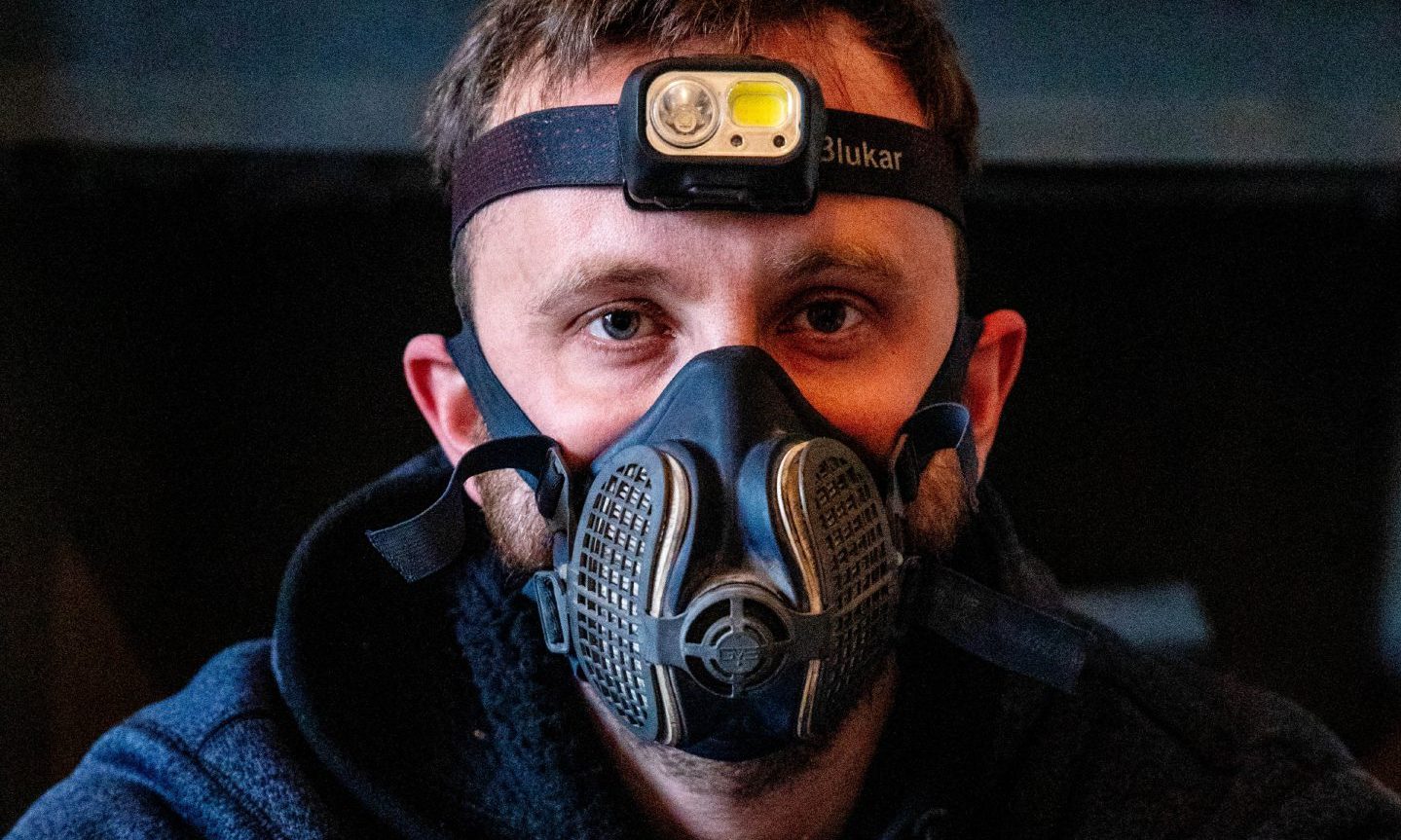
Dr Clare Maynard of the University of St Andrews is head of the Green Shores Partnership.
That is a collaboration between coastal landowners and community organisations that has created fringe saltmarsh habitat in key sections of degraded shoreline at the Eden estuary.
Multi-million pound seawalls and ‘managed realignment’ – where bits of land are given up to the sea to alleviate flooding elsewhere – are two existing approaches to managing sea level rise elsewhere.
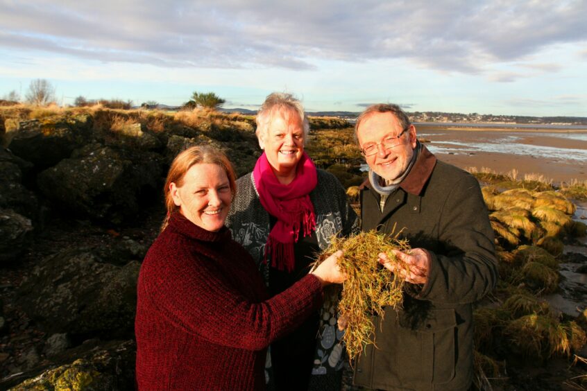
However, a third way is planting of saltmarshes, which are proven to reduce the impact of erosion and flooding of the land behind it.
Dr Maynard has been involved in this work for years. But in 2023 she was boosted by a grant from the Scottish Government’s Nature Restoration Fund, managed by Nature Scot.
She is now in the midst of a three-year project involving Royal Dornoch Golf Club, St Andrews Links Trust, Fife Council and the MoD, recruiting additional staff.
Saltmarsh restoration will not stop sea level rise or reduce storminess. But there’s growing evidence that saltmarsh development in estuaries will slow the impacts of storm damage. That effectively buys time in estuary environments.
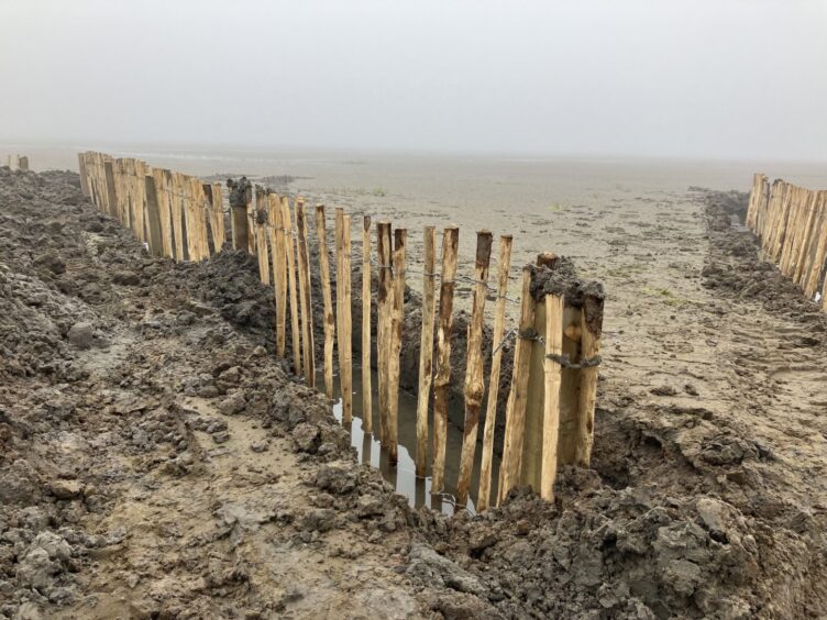
That’s why in the Eden estuary close to the fields purchased by St Andrews Links Trust at Kincaple, they’ve been experimenting by putting storm fencing into the silt, to break the energy from waves and protect new saltmarsh transplants.
This technique was developed by greenkeepers at Royal Dornoch and has been proven to work.
It’s hoped such measures could alleviate issues of coastal flooding and erosion and restore a valuable habitat.
In our series on coastal erosion, The Courier is highlighting the dangers of rising sea levels and destructive storms, and demanding councils and government act now before it is too late.


Conversation