Meall a’ Bhuachaille is perfect for giving children of all ages their first taste of hillwalking with plenty to keep them interested along the way.
There’s a good network of tracks and paths which make for easy walking, meanwhile the short climb up to the summit can be taken at a steady pace and is never too taxing.
The route starts from the car park at the Glenmore Forest Park visitor centre. Head north on a track to the left of the reindeer centre and when the track forks, take the right-hand branch which goes east, rising gently through the trees.
When the track runs out, continue in the same direction on a rougher, waymarked path which eventually descends over boardwalks and down some steps to meet another track coming in from the right beside the beautiful An Lochan Uaine.
You can also reach this point by taking the track in from the road end at Glenmore Lodge – my granddaughter Ava and I had come in from this way after being dropped off by her parents, concerned the day might prove too much for her. They needn’t have worried – she loved every minute.
The mixed woodland is a haven for birdspotting, and Ava was also fascinated by the variety of fungi along the way to the lochan.
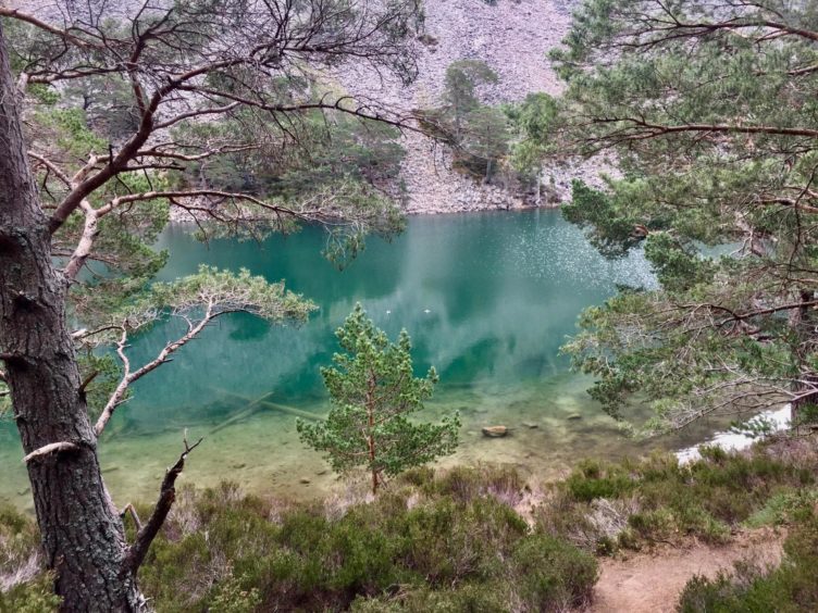
An Lochan Uaine translates as “the little green loch”. Legend has it that the waters get their green tinge from fairies washing their clothes, and it really captures the imagination of youngsters. A series of steps lead down to the water’s edge, a great spot for kids to have their first break of the day.
Fifteen minutes later we were back on the track. It starts to get a bit rougher, and some sections can hold a lot of standing water during or after heavy rain.
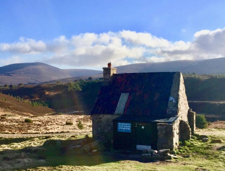
Where the track splits, we went left on the branch signed for Nethy Bridge and a kilometre further on reached the bothy at Ryvoan, another good stopping point place before the harder work begins. (Please note: the bothy is closed at the moment due to coronavirus restrictions).
The sun was now splitting the sky as we picked a spot on the grass for lunch. There were a few others with the same idea. We even had two collies stretched out keeping an eye on our packs. It seemed appropriate for a hill whose name is linked to shepherds and cattlemen.
The well-built hill path takes a direct line across the slope but the angle is moderate, and there was plenty of excuse to take regular breathers and soak up the views. To the north, the huge expanse of the Abernethy Forest stretched across the horizon, while down to our left the green slash of the lochan shone deep amidst the tree cover.
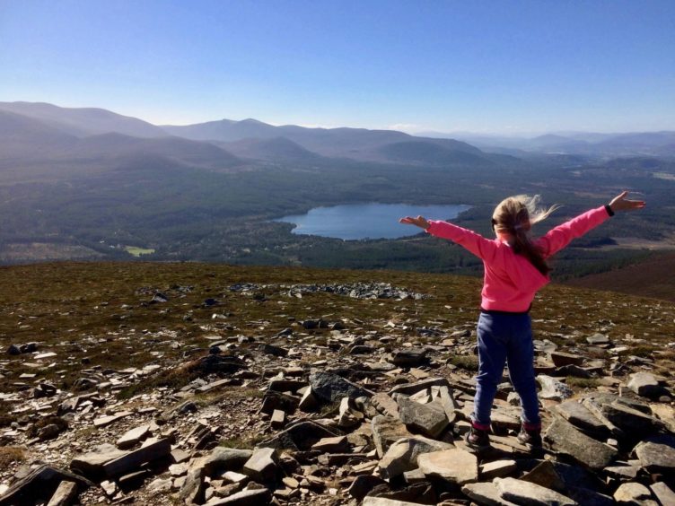
The path steepened with height, but it was short-lived and the gradient eased for the final push to the huge, sprawling wind shelter cairn. The summit views are expansive; Loch Morlich was a sparkling oasis far below, while the rolling slopes of the main Cairngorms massif dominated the skyline behind.
The drop to the muddy bealach with Creagan Gorm was swift and straightforward. Those wishing to extend the walk can head up to this next top then continue over to Craiggowrie and descend from there, but Ava had done her bit so we took the path south over open ground heading for the treeline.
The occasional distant bellowing of a stag was the only breach of the silence and as we lost height we passed the skeletal remains of ancient Scots pines, twisted into agonising poses. Once into the trees, the path soon converts to a track until it emerges from the trees where a signed path leads back to the visitor centre.
Route:
1. Leave car park to right of visitor centre and go left on track just before reindeer centre.
2. At a fork, turn right and follow rising track through trees until it ends, continue in same direction on waymarked path.
3. Soon the path merges with another track coming up from right beside An Lochan Uaine.
4. After a short detour to the lochan, return to the track and keep heading north-west and when it forks take the left branch signed for Nethy Bridge until you reach the bothy at Ryvoan.
5. Take the hill path on the left just before the bothy and climb steadily to the huge shelter cairn which marks the summit.
6. Continue west on the path to the low point between Meall a’ Bhuachaille and Creagan Gorm.
7. Drop left on the path to reach the treeline and then follow the orange markers through the trees until it becomes a track that leads back to the start.
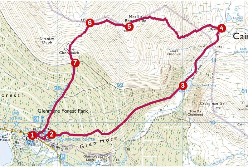
The Lowdown:
Distance: 8.2km/5 miles
Ascent: 480m/1575ft
Time: 3-5 hours
Grading: Circuit on good tracks and hill paths, steady climb for 1.5km to exposed summit, some muddy sections, tree roots which can be slippery when wet. Boots and adequate clothing required.
Start/finish: Glenmore Forest Park visitor centre (Grid ref: NH 976098). Parking charges apply.
Map: Ordnance Survey 1:50,000 Landranger Map 36 (Grantown & Aviemore); Ordnance Survey 1:25,000 Explorer sheet OL 57.
Tourist Information: Glenmore Forest Park visitor centre, Aviemore, PH22 1QU (Tel 01479 861220).
https://forestryandland.gov.scot/visit/forest-parks/glenmore-forest-park/glenmore-visitor-centre
Public transport: Bus and train services to Aviemore, local bus (31) Aviemore to Glenmore (
https://www.travelinescotland.com
).
You can follow Alan’s regular mountain adventures at munromoonwalker.com or on Facebook (Munro Moonwalker) and Twitter (@munromoonwalker)
