
It has been described as one of the most important ancient monuments in Western Europe.
But the Cleaven Dyke’s origins and purpose – whether perhaps as a ceremonial or burial site – remain a mystery.
Hidden deep in woodlands near the pretty village of Meikleour in Perthshire, the structure is essentially a vast prehistoric earthwork that stretches for more than a mile and a half.
It’s surprising how few people – even locally – are unaware of its existence.

I had vaguely heard of it years ago, but it wasn’t until I was in the area recently that I made it my mission to find it.
How do you find the Cleaven Dyke?
There are various ways of entering Meikleour Woods.
I parked behind the Meikleour Arms and walked up a well-maintained track with fields on either side.
Passing through a wooden gate, I stopped to admire a huge tree with a memorial bench underneath it.

Continuing straight ahead, I found myself quickly consumed by thick woodland and a burst of rhododendron.
I imagine it’s quite easy to get lost here – paths criss-cross through the woods in every direction.
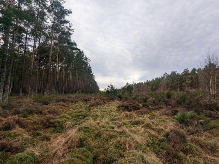
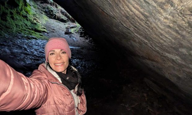
I wandered, slowly, gazing up in awe at huge Scots pines, until I reached what I assumed must be the Cleaven Dyke.
What is there to see?
Leaving the main path, my hunch became a certainty.
The land here was raised, and despite the dyke being covered in broom, gorse, heather and all sorts of random trees, saplings and bushes, it was clear that this was indeed it.
Keeping it free of such vegetation isn’t easy – and I heard, from a local, that it was last cleared, at great cost, about 20 years ago.
So it’s perhaps not the easiest to spot these days, unless you know exactly where to look.
If I’d had a drone, I’d have flown it up above the dyke, from where it would appear more obvious.

It’s straight as a runway and cuts diagonally through the north and south plantations of Meikleour Woods and across the A93 between Meikleour and Blairgowrie
I made do with a wee stroll down it, but quickly becoming encumbered by overgrown foliage, I decided to return to a much better maintained track.
What’s the history behind it?
So what indeed is the Cleaven Dyke? Will we ever really know?
It was built between two bends in the river and some think it might be an ancient ceremonial or burial site.
The dyke is described as a massive linear earthwork running for more than a mile and a half, comprising a pair of parallel ditches some 50m apart, with a raised central mound between them.
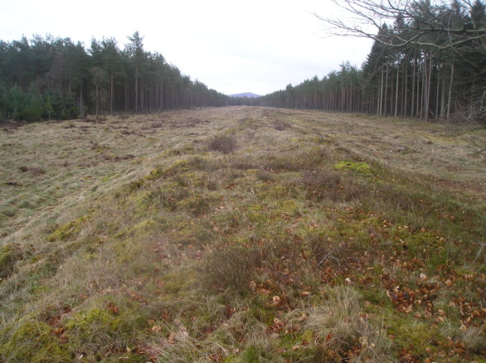
It’s about 9m wide and 1.8m high in places.
It was originally thought to be a Roman defensive structure, due to the closeness of a legionary fortress at Inchtuthil, near Spittalfield, four miles to the west, and a small, double-ditched signal station at Black Hill, to the south.
Cleaven Dyke dates from Neolithic times
However, carbon dating by archaeologists revealed the dyke was actually much older, dating from the Neolithic period.
It is of a type of ancient feature known as “cursus monuments” – Neolithic structures which date back to around 3000BC.
The purpose of a cursus is open to debate, but it may have been a ritual monument or perhaps a processional route.

The huge scale of the construction project suggests the landscape was well populated during Neolithic times.
It’s certainly one of Scotland’s most curious scheduled ancient monuments and well worth seeking out.
What else is there to see around Meikleour?
Sadly, the Cleaven Dyke is often overlooked by visitors whose attention is grabbed the famous Meikleour Beech Hedge.
This is recorded in the Guinness Book of Records as being the highest hedge in the world, at around 100ft.
Planted at the time of the Jacobite rebellion in 1745, it’s a memorial to many a warrior who fell at Culloden.

If you’ve got time for a wee look around Meikleour after checking out the hedge and Cleaven Dyke, you won’t be disappointed.
It’s packed with history: it’s fortunate in that it has remained much as it was in the 19th century.
Loads of listed buildings
It has an amazing amount of listed buildings – including the iconic red phone box.
In the centre of the village stands the Mercat Cross, dated 1698.

Nearby, in the grounds of Meikleour House, is a “tron” (weighing beam) – a link with the days when Meikleour was the commercial centre for a wide district.
Markets were often held in the village, but the big day was the fourth Friday of June, when an annual fair attracted buyers and sellers from across the country.
What about the tron?
The original tron, or stone pillar, stood near the centre of the village and was used for weighing wool and other bulky country produce, the scales being suspended from a wooden shaft.
The tron had another fascinating use. Attached to it were the “jougs”, or iron neck ring, in which delinquents were pilloried while they did penance for offences.
A short chain attached to a collar which could be fixed around a criminal’s neck as a type of stocks.

The original tron was damaged in 1832 but was replaced shortly afterwards.
Although they’re broken you can still see the “jougs” hanging from the tron and imagine ne’er-do-wells being mocked or having things thrown at them.

After all that exploring, I’d worked up an appetite, so popped into cosy Meikleour Arms for a warming bowl of soup.
The hotel has its own special place in history.
It was built in 1820 as a coaching and posting house, where the Inverness to Edinburgh coaches would stop to change horses and refresh their passengers.
It was later converted into a lodge used by fishing and shooting guests of Meikleour Estate, before becoming a popular hotel, restaurant and bar.


Conversation