Glen Tarken, St Fillans, Perth & Kinross
High above the northern shoreline of Loch Earn in Highland Perthshire, Glen Tarken boasts a hidden – and record-breaking – history. Beneath the valley’s wooded lower slopes and hilly moorland high ground, there lurks a secret subterranean world and, setting off from the eastern end of the loch, it was not long before I stumbled upon my first clue to its existence.
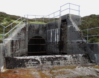
Climbing from the bus shelter by the Four Seasons Hotel, the road leading up into the glen passes St Fillans Power Station, although only the portal of the entrance tunnel is visible. Behind it, the hydro-electric turbine hall is secreted within a rocky cavern cut into the hill.
It takes its water from a pipeline running through Glen Tarken and from a reservoir in Glen Lednock, located four miles away over the hills to the north and connected to the power station by a network of tunnels.
Constructed by the celebrated ‘Tunnel Tigers’, who laboured on Scotland’s hydro-electric schemes during the mid-20th Century, they set a world record for rock digging here 65 years ago, chiselling out a 557-foot section in just seven days.
Water continues to course through this tunnel and my route through Glen Tarken would follow an excellent track laid down to service the scheme’s various tunnels, shafts and intakes.
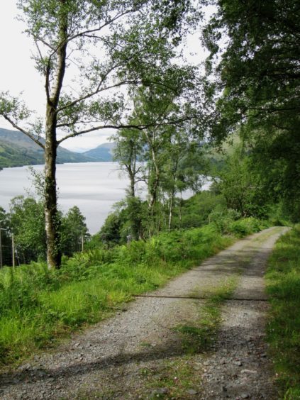
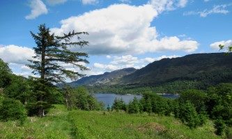
Crossing the line of the former Lochearnhead, St Fillans and Comrie Railway – now a walkway linking the three communities – and offering some fine views over Loch Earn, the track rises steadily through woodland, the gradient finally easing when it reaches a wooden gate by sheep pens and, beyond this, open moorland.
The ascent is not yet over but, going forward, it is rather less demanding, the way striking north, a pair of hairpin bends aiding the quest for height, before the track dips to cross Allt an Fhionn, one of many small streams feeding the turbine.
A final uphill pull guides the track over the southern slopes of craggy Meall Reamhar before a sustained and well-earned descent can be enjoyed, the route dipping past a line of old grouse butts to the next junction.

Here I branched left, continuing down to one of the pipeline intakes, but a longer outing can be had by proceeding straight ahead, up to the top of the glen, before looping back down its western flank (this adds 5km to the overall tally).
Down at the intake, the trail skirts by an old spoil heap before dropping to ford Glentarken Burn. Just upstream, there is a pleasant spot for a picnic and perhaps a paddle where the water pours over flat rock.
Above the ford, the trail meets the track coming down the western side of Glen Tarken and, joining it, I descended towards Loch Earn, passing sheep enclosures to reach a junction where I turned east, crossing back over Glentarken Burn, this time on an old bridge spanning a leafy wee gorge.
On grassy slopes beyond, a shepherd’s bothy is the last house standing in the abandoned village of Easter Glentarken, ruins of crofts emptied during the 19th Century Highland Clearances bordering the trail as it approaches Glentarken Wood.
A good path descends east through the trees to join the old railway and, like the waters of Glen Tarken, I flowed on from here to the power station and Loch Earn below.

ROUTE
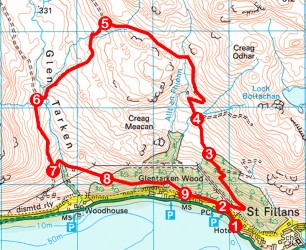
1. Behind bus shelter join and ascend minor road (signed Wester Glentarken) past power station to junction beyond The Shieling.
2. Turn right and, following signs for Wester Glentarken, ascend track to wooden gate at top of plantation.
3. Continue ahead, following track north over moorland.
4. Ignore track branching right at waymarked junction and continue ahead, swinging right and ascending through hairpin bends at next junction. Cross Allt an Fhionn and continue to next junction.
5. Turn left and follow track down to intake, up past spoil heap then down to ford Glentarken Burn.
6. Turn left and descend track to signed junction.
7. Turn left (signed St Fillans via Glentarken Wood), dipping over Glentarken Burn, and ascend to cottage. Continue ahead on waymarked path to enter woodland at gate.
8. Descend path through Glentarken Wood to former railway line.
9. Go left (signed St Fillans) then, at next waymarker post, branch right and descend track past viaduct to point 2. Retrace steps to Loch Earn.
Info:
Distance: 10km/6¼ miles
Ascent: 400m/1320ft
Time: 3 hours
Grading: Moderate route following waymarked track and paths through woodland and across open hillside with strenuous ascent initially. Keep dogs under close control over open ground where sheep graze
Start/finish: Bus stop by Four Seasons Hotel, St Fillans (Grid ref: NN 690244). Park in A85 laybys
Tourist Information: Perth iCentre, 45 High Street, Perth PH1 5TJ (Tel 01738 450600)
Public transport: Stagecoach bus service 15 from Perth to St Fillans via Crieff

