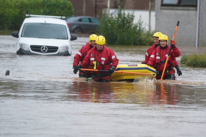
Storm Babet brought record-breaking rainfall to Tayside and Fife in October 2023.
The Met Office issued an 18-hour red warning covering Angus from 6pm on October 19 2023, as Storm Babet hit with full force.
The exceptional rainfall and severe flooding resulted in the death of at least seven people across the UK.
In terms of rain, Angus was undeniably worst hit in Scotland.
Two thirds of the 15 monitoring stations in Angus recorded more than 100mm during the storm.
Out of 270 stations, only 22 recorded more than 100mm of rain over the four-day period.
However, 10 of those 22 stations were in Angus.
Five were in Aberdeenshire, two in Perth and Kinross and two in the Highlands.
Additionally, Moray and East Lothian each had one station which recorded just over 100mm.
Meanwhile, the west of the country took less of the rainfall than the characteristically drier east.
How Met Office measured rainfall
In fact, the east of Scotland had its wettest October on record, based on Met Office data stretching back to 1836.
We analysed the monthly rainfall stations across Tayside and Fife so we could show how extreme the rainfall was.
Across this area, the rainfall observed in October of last year surpassed monthly totals recorded in the preceding five years – as well as the months since.
In Angus, 11 of the 15 stations soared above the five-year monthly record with Storm Babet.
Above all other stations, Waterside Perth, on the North Esk near Brechin, recorded a staggering 412.4mm in October 2023.
Dundee’s only monitoring station, Baluniefield, also saw a five-year high when Storm Babet brought severe rainfall.
A total of 8 from 13 which recorded data that month in Fife also saw a five-year peak.
Meanwhile, in Perth & Kinross, 7 of 19 stations peaked with Storm Babet. Overall, the storm saw the wettest October across 21 monitoring stations in Tayside and Fife.
For eleven stations in the area, October 2023 saw more rainfall than any month on record. That includes five in Angus and Dundee’s only monitoring station.
In Fife, the Rossie Farm station recorded 228.6mm in the month of October last year – breaking a record of 201.4mm in August 2004. But the data for the station itself extends back to 1996.
Yet for some stations the record-breaking figure would have been easier to hit. For example, Carmyllie-Hume Farm station in Angus only has data going back to 2020.
Angus hit badly by flooding
Ahead of the South Esk river bursting its banks, Angus Council evacuated hundreds of homes in Brechin.
On the Thursday morning, emergency crews used boats to search flooded homes and rescue dozens of further households.
Almost a year on, council homes in the worst hit area around River Street remained uninhabitable.
Storm Babet saw rivers reach record-breaking heights at eight monitoring stations in Scotland. Half of those were in Angus.
Each of those Angus stations fell within the Esk Group catchment.
But the surge can be backtracked in Angus.
The record breaking started on one of the South Esk’s main tributaries – Prosen Water at 11pm.
The river reached a height of 2.62m, surpassing records dating back to 1984.
The North Esk and its Angus tributary West Water reached record heights earlier in the night.
Dalhousie Bridge, in Angus, was the first station to break its previous record.
In Aberdeenshire, three stations also surpassed their all-time records. And two of those, Logie Mill and Inveriscandye, were on the river North Esk.
What caused Storm Babet?
Autumn and winter storms tend to track west to east and clear eastward into the North Sea, a Met Office spokesperson explained.
But Storm Babet travelled from south to north, allowing it to “pick up additional moisture as it crossed the Bay of Biscay”.
However, an area of high pressure across Scandinavia stopped it in its tracks.
Andrea Bishop said: “Babet was also unable to clear eastward into the North Sea due to a blocking area of high pressure across Scandinavia.
“The rain-bearing fronts therefore remained stationary across eastern Scotland for a prolonged period before moving back across England and Wales.
Why is it called Storm Babet?
The last storm season, running up until the end of August, brought 12 named storms.
The final storm – they are named in alphabetical order – was storm Lillian.
That is the furthest through the naming list the Western European naming group has got since storm naming was introduced in 2015.
Andrew continued: “Storm seasons are highly variable in the UK, with some seasons seeing a low frequency of named storms, and others more.
“One reason there were so many storms last year was the position of the jet stream through much of autumn and winter, which brought a succession of low-pressure systems towards the UK which became named storms.”
Keeping our readers informed ahead of the storm
The Courier data journalism team have been busy preparing for adverse weather events that impact our readers across Tayside, Fife and Stirling.
We aim to be able to provide you with up-to-the-minute data in detailed charts and interactive maps.
By monitoring the data we want to provide you with all the tools you need to stay informed and prepared.
If there’s anything specific you’d like us to cover or explore, let us know in the comments below – your feedback is important in shaping our reporting.
One year on, the Courier team also returned to Brechin to hear of some residents’ plights.


Conversation