Calendar An icon of a desk calendar. Cancel An icon of a circle with a diagonal line across. Caret An icon of a block arrow pointing to the right. Email An icon of a paper envelope. Facebook An icon of the Facebook "f" mark. Google An icon of the Google "G" mark. Linked In An icon of the Linked In "in" mark. Logout An icon representing logout. Profile An icon that resembles human head and shoulders. Telephone An icon of a traditional telephone receiver. Tick An icon of a tick mark. Is Public An icon of a human eye and eyelashes. Is Not Public An icon of a human eye and eyelashes with a diagonal line through it. Pause Icon A two-lined pause icon for stopping interactions. Quote Mark A opening quote mark. Quote Mark A closing quote mark. Arrow An icon of an arrow. Folder An icon of a paper folder. Breaking An icon of an exclamation mark on a circular background. Camera An icon of a digital camera. Caret An icon of a caret arrow. Clock An icon of a clock face. Close An icon of the an X shape. Close Icon An icon used to represent where to interact to collapse or dismiss a component Comment An icon of a speech bubble. Comments An icon of a speech bubble, denoting user comments. Comments An icon of a speech bubble, denoting user comments. Ellipsis An icon of 3 horizontal dots. Envelope An icon of a paper envelope. Facebook An icon of a facebook f logo. Camera An icon of a digital camera. Home An icon of a house. Instagram An icon of the Instagram logo. LinkedIn An icon of the LinkedIn logo. Magnifying Glass An icon of a magnifying glass. Search Icon A magnifying glass icon that is used to represent the function of searching. Menu An icon of 3 horizontal lines. Hamburger Menu Icon An icon used to represent a collapsed menu. Next An icon of an arrow pointing to the right. Notice An explanation mark centred inside a circle. Previous An icon of an arrow pointing to the left. Rating An icon of a star. Tag An icon of a tag. Twitter An icon of the Twitter logo. Video Camera An icon of a video camera shape. Speech Bubble Icon A icon displaying a speech bubble WhatsApp An icon of the WhatsApp logo. Information An icon of an information logo. Plus A mathematical 'plus' symbol. Duration An icon indicating Time. Success Tick An icon of a green tick. Success Tick Timeout An icon of a greyed out success tick. Loading Spinner An icon of a loading spinner. Facebook Messenger An icon of the facebook messenger app logo. Facebook An icon of a facebook f logo. Facebook Messenger An icon of the Twitter app logo. LinkedIn An icon of the LinkedIn logo. WhatsApp Messenger An icon of the Whatsapp messenger app logo. Email An icon of an mail envelope. Copy link A decentered black square over a white square.

Geologists take fresh look at 400 million-year-old landscape of Strathmore in major mapping survey

The British Geological Survey project will update ancient maps of Strathmore from the 1880s, venturing into Perthshire during the three-year study.

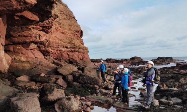
British Geological Survey (BGS) experts at Arbroath cliffs. Image: BGS/UKRI

Experts are to survey the ancient terrain of Strathmore in the area’s first major mapping survey for almost a century and a half.

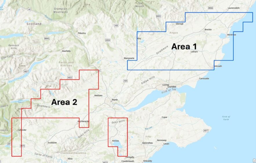
In a three-year project, the British Geological Survey will gather data from Montrose to Crieff.

And scientists will harness modern technology to chart the changes in a landscape laid down 400 million years ago.

The area was last surveyed in the 1880s.

Field studies are already under way and will continue in September 2024 and spring 2025.

Those are being done on foot, making observations of rock exposures, soils and the form of the landscape.

Geological maps will then be drawn up using the field observations alongside analyses of borehole records and historic maps.

And the picture will be enhanced by modern digital terrain models and aerial photos.

BGS survey geologist and project lead Katie Whitbread said: “The Strathmore area was last surveyed nearly 100 years before we knew about plate tectonics and before there were aerial photos.

“With this re-survey, we can re-shape our understanding of a key part of Scotland’s geological past by looking at these rocks and structures with new eyes, both in the field and using modern digital data resources.”

Famous red sandstone

The geology of the region includes the sandstones, siltstones and conglomerates of the ’Old Red Sandstone’.

Those were deposited by rivers in hot and dry conditions some 400 million years ago in the Devonian Period.

The reddish colour of these rocks and the rich soils derived from them are characteristic of the region – from Arbroath cliffs to the fertile Vale of Strathmore.

British Geological Survey of Strathmore.
The study areas of the three-year British Geological Survey project. Image: BGS

The higher ground of the Ochil Hills is underlain by volcanic rocks, which are typically associated with acidic soils.

It is hoped to gain a new understanding of how they have been deformed by faulting and folding.

BGS also hope the results will create a better understanding of ground conditions and the pathways for groundwater flow.

It could help assessments of geothermal resource potential.

In the future, this will help farmers and other rural businesses identify more reliable groundwater sources and make decisions around investment in ground-source heat pumps.

Geological maps produced from the project will form part of the national geological map.

It can be freely viewed on the BGS maps portal or on the GeoIndex (onshore) on the BGS website.

Research papers and reports will also be accessible via the BGS website and NERC Open Research Archive services.
Conversation