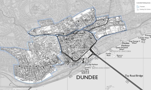
The streets that are likely to be affected by new residents’ parking schemes around Dundee city centre have been outlined in an interactive map compiled by the council.
The proposals for £62-a-year residents’ parking permits in the West End, Coldside and Maryfield areas came up before councillors earlier this week and will now be the subject of consultation with the communities in the affected areas.
While that might mean alterations to the final boundaries, the council’s initial plans give a good indication of how far it believes the new restrictions should extend around the city centre.
The West End zone
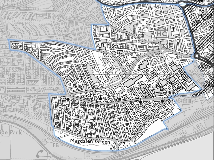
In the West End, the residents’ parking zone would extend as far west as Windsor Street, Blackness Avenue, part of Balgay Road, Forest Park Road and Milnbank Road.
Its northern boundary would be Lochee Road, and then encompass West Marketgait and through the Dundee University campus at Park Place south to the Seabraes Court area and Magdalen Green.
The Coldside zone
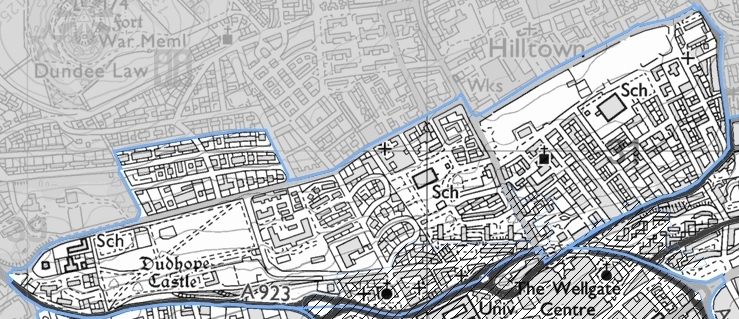
The southern boundary of the Coldside zone extends from Lochee Road to North Marketgait to Victoria Road. Its eastern limit is Dens Road, then extending west along Alexander Street, Constitution Street, Somerville Place, Drummond Street, Adelaide Terrace, Inverlaw Place and Dudhope Terrace to Lochee Road.
The Maryfield Zone
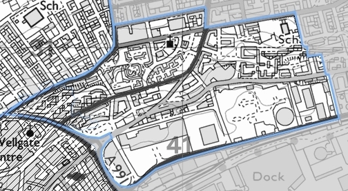
The Maryfield zone begins at East Marketgait, along Dock Street as far as Market Street, and then north to Baffin Terrace and Baffin Street before joining the Arbroath Road. Heading west, it cuts up Albert Street to Lyon Street as far as Dens Road and back to East Marketgait.
On the border
While the residents’ permit scheme has been welcomed by many who agree action needs to be taken to stamp out problem parking, there has also been opposition — including on the council’s own Facebook page.
Some of the complaints have come from people who worry that the new zones will simply transfer the problems to streets just outside the restricted zones.
The initial proposals show a number of residential streets that would lie immediately outside the boundaries.
In the West zone these include Minto Place, Shaftesbury Road, Shaftesbury Terrace, Seymour Avenue, Seymour Street, Hyndford Place and Hyndford Street.
Elm Street, Glenagnes Street, Ashbank Road, Glenagnes Road, Rosefield Street, Lawrence Street, Fyffe Street and Cleghorn Street are others that skirt the West zone’s boundary.
In Coldside, some of the bordering streets include parts of Albany Terrace, Adelaide Place, Law Street, North Somerville Place, West Somerville Place, Lawson Place, Ogilvie’s Road, Rosebank Street, James Street, Carnegie Street, North Wellington Street, North Ellen Street, North William Street and Hillbank Road.
In the Maryfield zone, neighbouring streets include parts of Broughty Ferry Road, Eden Terrace, Morgan Street, Kemback Street, Erskine Street, Brown Constable Street and Cunningham Street.
More information
The suggested boundaries can be explored on this interactive map.
