An extensive detailed record of Fife areas which endured severe disruption due to unprecedented flooding last August has been created in a bid to avoid a repeat.
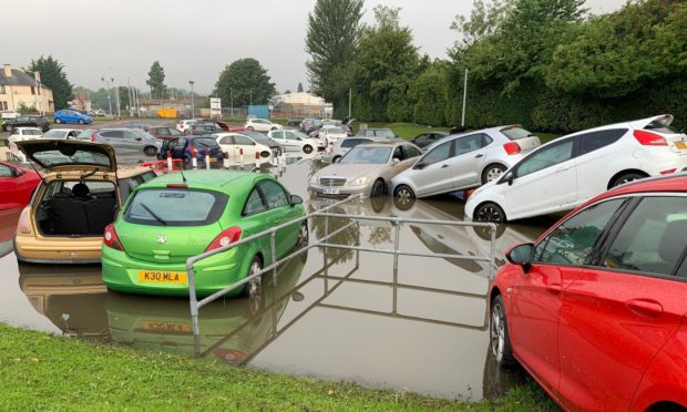
Extreme rainfall events on August 11 and 12, and again on August 25, brought biblical rain to many location across the region, causing damage to roads, structures, private properties and council buildings as well as disruption of vital services.
Experts even revealed that the amount of rainfall recorded at a gauge at Fife Airport near Glenrothes was a one in 1,000 year event, while the sight of vehicles fully submerged and floating around Kirkcaldy’s Victoria Hospital car park is not one which will be forgotten in a hurry.
With many residents left to pick up the pieces following devastating flooding, Fife Council has now produced a list of 430 hotspots in a bid to fully understand the extent of the flooding and how it might be prevented in future.
That work was carried out after locals in some of the worst-hit communities claimed there had been a lack of co-ordination between Fife Council and external agencies when flooding hit.
Ken Gourlay, head of assets, transportation and environment at Fife Council, said it was important to build up a picture of where flooding events have and might happen to increase the resilience of communities.
“Climate change is here to stay and the impacts of such storm events in late 2020 require equivalent levels of investigation and design to deliver mitigation measures to manage repeat flooding in the same locations,” he explained.
“The flood events of August were extensive causing flooding throughout South Fife.
“However, not all events were reported to Fife Council by the affected residents of Fife.
“This register of events will inform what mitigation measures, if any, are required going forward as well as examine a holistic approach, based on a lessons learnt exercise from August 2020, on how Fife Council can look to manage future flood events.
“Given this additional information and the evidence of additional sites impacted by weather events, this reinforces the need for additional resources to deliver any measures required.”
All of the sites have been assessed through a red/amber/green risk assessment and initial investigation of the red sites is being progressed through site investigation which includes CCTV inspection of drainage networks affected.
Over the last four years nine flood risk studies have been completed, seven are in progress with four more to be started this year.
In addition, seven maintenance projects for existing flood prevention schemes are also being carried out.
Defending the council’s efforts when flooding did strike in August, Mr Gourlay added: “It is incredibly difficult to predict where these problems are going to come.
“It’s incredibly difficult to make that pre-emptive move.
“We need to work with communities on resilience so people can protect their properties.
“Hopefully we’ll never see this level of flooding again but it is important to build that resilence.”
Number of records per council ward:
Ward 1 – West Fife & Coastal Villages 34
Ward 2 – Dunfermline North 2
Ward 3 – Dunfermline Central 5
Ward 4 – Dunfermline South 4
Ward 5 – Rosyth 23
Ward 6 – Inverkeithing & Dalgety Bay 28
Ward 7 – Cowdenbeath 21
Ward 8 – Lochgelly, Cardenden & Benarty 30
Ward 9 – Burntisland, Kinghorn & Western Kirkcaldy 57
Ward 10 – Kirkcaldy North 22
Ward 11 – Kirkcaldy Central 21
Ward 12 – Kirkcaldy East 7
Ward 13 – Glenrothes West & Kinglassie 37
Ward 14 – Glenrothes North, Leslie & Markinch 30
Ward 15 – Glenrothes Central & Thornton 37
Ward 16 – Howe of Fife & Tay Coast 20
Ward 17 – Tay Bridgehead 3
Ward 18 – St Anderws 7
Ward 19 – East Neuk 2
Ward 20 – Cupar 18
Ward 21 – Leven, Kennoway & Largo 9
Ward 22 – Buckhaven, Methil & Wemyss Villages 13
Grand Total: 430
