Calendar An icon of a desk calendar. Cancel An icon of a circle with a diagonal line across. Caret An icon of a block arrow pointing to the right. Email An icon of a paper envelope. Facebook An icon of the Facebook "f" mark. Google An icon of the Google "G" mark. Linked In An icon of the Linked In "in" mark. Logout An icon representing logout. Profile An icon that resembles human head and shoulders. Telephone An icon of a traditional telephone receiver. Tick An icon of a tick mark. Is Public An icon of a human eye and eyelashes. Is Not Public An icon of a human eye and eyelashes with a diagonal line through it. Pause Icon A two-lined pause icon for stopping interactions. Quote Mark A opening quote mark. Quote Mark A closing quote mark. Arrow An icon of an arrow. Folder An icon of a paper folder. Breaking An icon of an exclamation mark on a circular background. Camera An icon of a digital camera. Caret An icon of a caret arrow. Clock An icon of a clock face. Close An icon of the an X shape. Close Icon An icon used to represent where to interact to collapse or dismiss a component Comment An icon of a speech bubble. Comments An icon of a speech bubble, denoting user comments. Comments An icon of a speech bubble, denoting user comments. Ellipsis An icon of 3 horizontal dots. Envelope An icon of a paper envelope. Facebook An icon of a facebook f logo. Camera An icon of a digital camera. Home An icon of a house. Instagram An icon of the Instagram logo. LinkedIn An icon of the LinkedIn logo. Magnifying Glass An icon of a magnifying glass. Search Icon A magnifying glass icon that is used to represent the function of searching. Menu An icon of 3 horizontal lines. Hamburger Menu Icon An icon used to represent a collapsed menu. Next An icon of an arrow pointing to the right. Notice An explanation mark centred inside a circle. Previous An icon of an arrow pointing to the left. Rating An icon of a star. Tag An icon of a tag. Twitter An icon of the Twitter logo. Video Camera An icon of a video camera shape. Speech Bubble Icon A icon displaying a speech bubble WhatsApp An icon of the WhatsApp logo. Information An icon of an information logo. Plus A mathematical 'plus' symbol. Duration An icon indicating Time. Success Tick An icon of a green tick. Success Tick Timeout An icon of a greyed out success tick. Loading Spinner An icon of a loading spinner. Facebook Messenger An icon of the facebook messenger app logo. Facebook An icon of a facebook f logo. Facebook Messenger An icon of the Twitter app logo. LinkedIn An icon of the LinkedIn logo. WhatsApp Messenger An icon of the Whatsapp messenger app logo. Email An icon of an mail envelope. Copy link A decentered black square over a white square.

Fears hundreds of new Cupar North residents could be sent via narrow, potholed road

The C-class road is highlighted as a quickest route between Cupar and Dundee.

A CGI image of how the new Cupar North homes will look.
A CGI image of how the new Cupar North homes will look. Image: Supplied by Persimmon Homes.

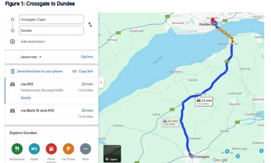
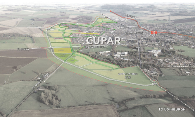
Sat nav could send hundreds of new Cupar residents to Dundee via an unsuitable C-class road, it has been claimed.

The navigation system already highlights the C29 as the quickest route from the centre of town to Dundee and the north.

Sat nav says the C29 is the fastest route between Cupar and Dundee

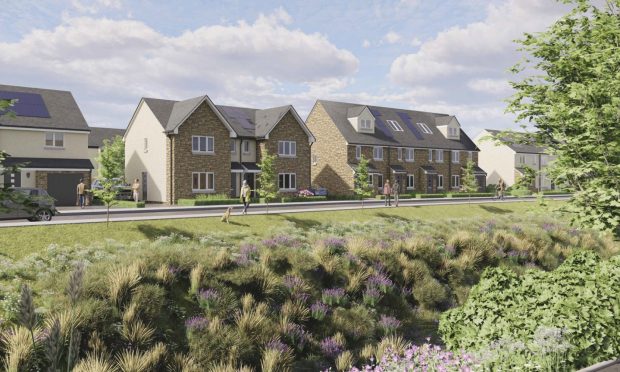
And many residents fear the proposed 1,500 new homes at Cupar North will swamp the narrow, potholed road.

The winding route joins Bank Street with the A92, via Cairnie Fruit Farm and Rathillet.

However, application objector Jennifer Quinn says it has been excluded from traffic data submitted with the Cupar North planning application.

And she said: “A 50% increase in Cupar’s population without any thought to improve the condition of that road is not acceptable.”

Cupar sat nav route ‘in a state of disrepair’

Jennifer is one of 577 people who have objected to the Cupar North planning application.

She points out all other routes to Dundee, including via Dairsie, Bonnygate and Balgarvie Road, were studied in an environmental impact assessment.

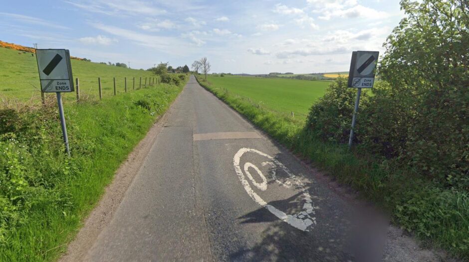
However, the C29 was not.

And she says: “The C29 is in a state of disrepair.

The C29 between Cupar and the A92 is recommended by sat nav
The C29 between Cupar and the A92. Image: Google.
The C92 is a narrow countryside route. Image: Google.

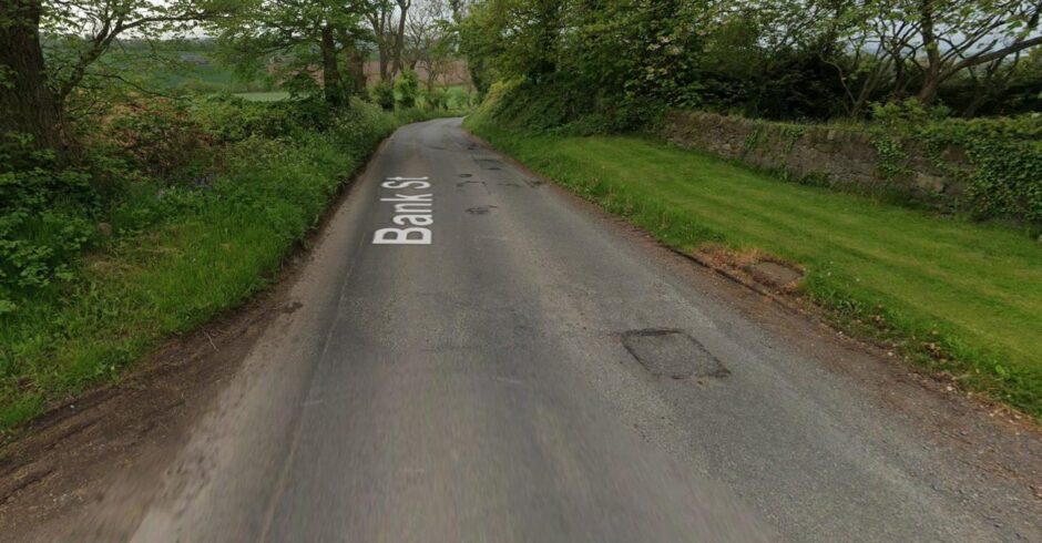
“It is an unkerbed road, immediately adjacent to the verge, and is currently suffering from edge failure.

“This is a result of cars passing along the edge of the road where there is no supporting structure under the road surface.

“Cars currently drive towards the centre of the road to avoid these potholes.”

Road network has ‘adequate capacity’

Jennifer adds: “The C29 is the only C-class road serving as a recommended route from the centre of Cupar.

“We have concerns that the increase in traffic along this road will require significant ongoing financial investment from Fife Council to ensure the safety of its residents, commuters and visitors.”

A graphic showing a plan of the proposed new housing development at Cupar North.
A graphic showing the site of the proposed new housing development at Cupar North.

Applicant Persimmon Homes predicts the development will result in increased traffic around the town.

But it says the road network has adequate capacity and will continue to operate well.

The housebuilder adds that its relief road to the north of the development will help mitigate any problems.

Cupar North application includes 1,001 documents

Meanwhile, other objections to the Cupar North development include fears over flooding, traffic in the town centre and an increase in demand on medical services.

The Persimmon Homes application is one of the biggest in north east Fife’s history.

It will increase the size of Cupar by 30% and includes a relief road with two roundabouts.

And it also includes 1,001 documents.

The period to submit public comments closed on July 8.

Conversation