Calendar An icon of a desk calendar. Cancel An icon of a circle with a diagonal line across. Caret An icon of a block arrow pointing to the right. Email An icon of a paper envelope. Facebook An icon of the Facebook "f" mark. Google An icon of the Google "G" mark. Linked In An icon of the Linked In "in" mark. Logout An icon representing logout. Profile An icon that resembles human head and shoulders. Telephone An icon of a traditional telephone receiver. Tick An icon of a tick mark. Is Public An icon of a human eye and eyelashes. Is Not Public An icon of a human eye and eyelashes with a diagonal line through it. Pause Icon A two-lined pause icon for stopping interactions. Quote Mark A opening quote mark. Quote Mark A closing quote mark. Arrow An icon of an arrow. Folder An icon of a paper folder. Breaking An icon of an exclamation mark on a circular background. Camera An icon of a digital camera. Caret An icon of a caret arrow. Clock An icon of a clock face. Close An icon of the an X shape. Close Icon An icon used to represent where to interact to collapse or dismiss a component Comment An icon of a speech bubble. Comments An icon of a speech bubble, denoting user comments. Comments An icon of a speech bubble, denoting user comments. Ellipsis An icon of 3 horizontal dots. Envelope An icon of a paper envelope. Facebook An icon of a facebook f logo. Camera An icon of a digital camera. Home An icon of a house. Instagram An icon of the Instagram logo. LinkedIn An icon of the LinkedIn logo. Magnifying Glass An icon of a magnifying glass. Search Icon A magnifying glass icon that is used to represent the function of searching. Menu An icon of 3 horizontal lines. Hamburger Menu Icon An icon used to represent a collapsed menu. Next An icon of an arrow pointing to the right. Notice An explanation mark centred inside a circle. Previous An icon of an arrow pointing to the left. Rating An icon of a star. Tag An icon of a tag. Twitter An icon of the Twitter logo. Video Camera An icon of a video camera shape. Speech Bubble Icon A icon displaying a speech bubble WhatsApp An icon of the WhatsApp logo. Information An icon of an information logo. Plus A mathematical 'plus' symbol. Duration An icon indicating Time. Success Tick An icon of a green tick. Success Tick Timeout An icon of a greyed out success tick. Loading Spinner An icon of a loading spinner. Facebook Messenger An icon of the facebook messenger app logo. Facebook An icon of a facebook f logo. Facebook Messenger An icon of the Twitter app logo. LinkedIn An icon of the LinkedIn logo. WhatsApp Messenger An icon of the Whatsapp messenger app logo. Email An icon of an mail envelope. Copy link A decentered black square over a white square.

Met Office puts Dundee, Perthshire, Angus and Fife on thunder alert for two consecutive days

The Met Office has put Courier Country on thunder alert with two weather warnings in two days.

The forecaster says thunderstorms may bring disruption to Dundee, Perthshire, Angus and Fife on Tuesday and Wednesday.

The majority of Scotland is covered by a yellow weather warning on both days, with two to three inches of rain is forecast across all of Scotland this week.

A 1,200-mile wide storm system will be first to hit, until Wednesday, with Scotland deluged.

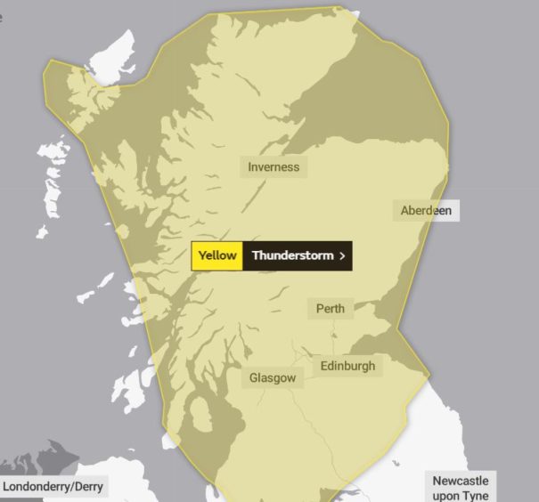
The area covering the weather alert for Tuesday.

On Tuesday, the Met Office says thunder could hit between 11am and 10pm. The warning says: “Spray and sudden flooding could lead to difficult driving conditions and some road closures.

“Power cuts might occur and other services to some homes and businesses could be lost.

“Where flooding or lightning strikes occur, there is a chance of delays and some cancellations to train and bus services.

“Flooding of homes and businesses could happen quickly, with damage to some buildings from floodwater, lightning strikes, hail or strong winds.”

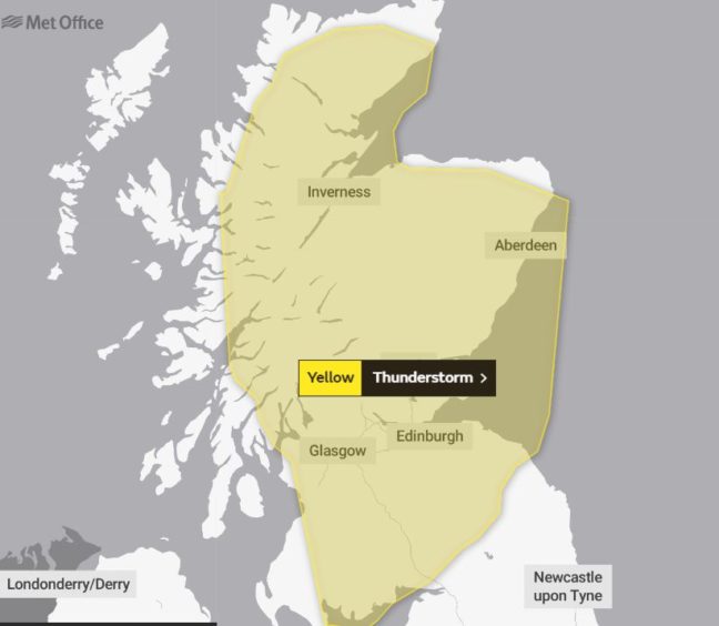
The area covering the weather alert for Wednesday.

The thunder alert in place on Wednesday, valid between 11am and 10pm, echoes the warnings above.

A second low pressure zone is due to arrive from Friday to Sunday, bringing more rain.

Two further low pressure systems are predicted for the following week.

However, weathermen said summer “isn’t over”. The Met Office said hotter and drier conditions, with temperatures up to 25C, are expected in the second half of this month.

The Met Office’s contingency forecast shows there is a 60% probability of this month having August’s hottest UK average temperature since 2004’s 16.1C.

Met Office forecaster Mark Wilson said: “There’s potential for high rainfall totals as low pressure dominates the next week across the country.

“We’re closely monitoring further warnings.

“The first low pressure brings heavy showers until Wednesday, heaviest in the North and West, and the next low pressure from Friday brings showers for the weekend.

“Unsettled conditions will probably persist until mid-month.

“After August 17 (there are) signs high pressure could build.

“There is the chance of warmer interludes, perhaps more widely later in the month.”